
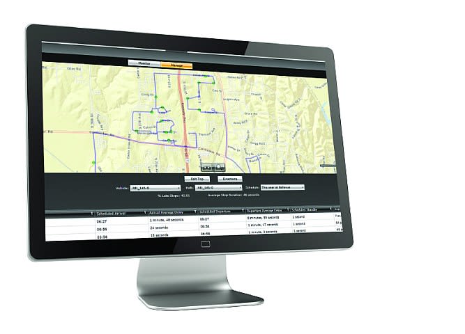
Routing Solutions Target Transportation Efficiency
The latest programs for school bus routing can help school bus operations build safe and efficient routes while integrating with other fleet management functions, including GPS, driver monitoring, and KPI tracking.

Route optimizer for time, fuel savings
Radio Engineering Industries (REI) has added route optimization and driver monitoring to its software solutions. REI’s routing software uses a cellular connection to identify if a bus is off route or running late. Past routes can be optimized to save time and fuel by automatically generating the most efficient path available, according to the company. REI’s driver monitoring software can be used to observe video events with the goal of improving and adjusting driver performance and behavior. The software’s RFID technology provides identification of drivers and creates a single-page report to track their progress. Automatic alerts can be configured for events of importance, such as a late bus or driving over 65 mph, so that immediate action can be taken. REI’s new software solutions can be combined with existing A.R.M.O.R. software extensions.
www.radioeng.com

Web-based program for routing, data
Seon’s vMax Compass is a completely web-based school transportation solution, with no application to install and no map data to download. Everything from route building to school boundary information and transportation eligibility is accessible by authorized users from any computer. Also, updates to software functionality are immediately available to all users. The program’s integration with ESRI enables the use of ArcGIS to create or update map data and view or use that map data within the vMax Compass routing software. According to Seon, this customized mapping information gives transportation staff a richer visual of their routing operations — especially critical in emergency situations, such as a tornado, where transportation conditions and accessible routes can change quickly. VMax Compass is integrated with live GPS tracking data, student tracking, and driver management solutions.
www.seon.com
Personalized dashboard, reports
Transfinder has released Viewfinder 2.0, which includes new features and enhancements. Viewfinder enables school district officials to monitor the day-to-day operations of the transportation department from any device. Users can access updates on students, trips, vehicles, staff, and field trips. Viewfinder also allows users to personalize their dashboard, so they see only what they want to see. Users can also schedule and manage reports, and they can compare data from one year to the next to spot trends in ridership and to determine the efficiency of the transportation operation. Other features include the ability to search a geographic area for data, and GPS integration for real-time and historical views. A timeline has been added to the dashboard, allowing users to review trips as the day progresses. A playback feature can be used to review an entire day’s data.
www.transfinder.com

Compare, rewind school bus routes
AngelTrax’s MotoTrax online surveillance manager offers a fixed route comparison feature. School bus routes can be compared by using up to eight color-coded trails at a time to identify unnecessary duplication and detours. Routes can be saved by bus number, date, and time of day for detailed analysis to reduce fuel costs and enhance the efficiency of the fleet, according to AngelTrax. With MotoTrax’s route rewind feature, a vehicle’s full route can be played back to review the events that occurred and to watch where it traveled, stopped, and idled from the operator’s perspective. Other features of MotoTrax include live tracking and live view, geo-fencing, fleet reports, dynamic event organization, dashboard with system summary, system health alerts, and remote setup.
www.angeltrax.com
Tracking, reporting features added
In recent releases of Tyler’s Versatrans Routing & Planning, features have been added that allow school districts to track and report on the number of hours that school bus drivers are scheduled to drive in order to monitor compliance with the Affordable Care Act, as well as to more easily plan and account for driver park-outs. Also, more use has been made of file attachments and the packaging of routes, making information readily available for routers and dispatchers. Automated processes have been added, offloading the need for district personnel to periodically run data maintenance routines. Once built, Versatrans routes integrate with the rest of Tyler’s transportation software suite, including the e-Link parent portal, the Onscreen GPS aggregator, the My Stop mobile app for parents, and the new onboard tablet solution, Tyler Drive.
www.tylertech.com

Route around busy streets, predators
Education Logistics’ (Edulog’s) routing and planning software offers advanced optimization algorithms that help school districts create efficient routes to save money and improve service to the community, according to Edulog. GPS, student ridership management, and parental notification are done in real time to enhance student safety and school district accountability. The Edulog system also includes tablets on the buses so that drivers can receive route changes, view maps of their routes, and know where each student needs to be. Extensive “what if” capabilities and a true GIS interface enable users to manage by exception with the Edulog system.
www.edulog.com

Scheduling algorithm aids analysis
TripSpark Education offers VEO Transportation, a school bus routing program that uses GPS data, calendars, and a scheduling algorithm to help school districts manage their operations. The fully integrated calendar enables districts to maintain past, current, and future transportation data in one database. Historical scheduling and student data can be accessed by selecting a date from a calendar. Also, maintenance for the current and planning for the upcoming school year can be managed in parallel. The scheduling algorithms give users the ability to adjust district parameters to create “what if” scheduling scenarios for analysis. VEO Transportation also allows for various map displays to assist users when scheduling. This includes the district map, a street view, and satellite images.
www.tripspark.com

New feature compares school bus KPIs
The latest release of BusBoss includes numerous new features. BusBoss Benchmarks takes a measurable approach to school bus route optimization on a recurring basis, comparing a district’s key performance indicators (KPIs) to national medians. The new BusBoss Dashboard shows the percentage of completion for important items, such as students with missing information, overloaded routes, and buses with incomplete information. Also, BusBoss now includes an option to show a satellite view (pictured) within the primary map display area. According to the company, this enhances users’ ability to identify correct addresses or stop locations, edit routes, and identify new streets that need to be added or modified. Another new feature uses TomTom map data location attributes to accurately locate addresses based on latitude and longitude coordinates.
www.busboss.com
More Management

Tennessee Hall of Fame Honors Drivers for Decades of Service
Frances Theiring, a school bus driver for Wilson County Schools, retires this year after almost 50 years on the road. She is one of two long-time drivers honored for their service in the state.
Read More →
What Happens to a School Bus After Retirement? First Student Has a New Answer
Through a new partnership with Advanced Remarketing Services, proceeds from retired vehicle sales will support Special Olympics and other community-focused organizations while advancing sustainability goals.
Read More →
School Bus Logistics Adds 3 Data Analysts, Expands Routing Capabilities
Three new data analysts and a BusRight certification bring an added layer of support to the routing services districts already use.
Read More →


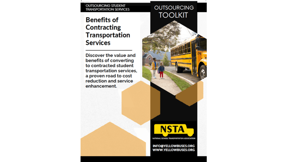
Outsourcing Student Transportation Services Toolkit
Did you know nearly 40% of school districts utilize a private contractor to serve their transportation needs? Explore why more school leaders are turning to contracted transportation services, and how outsourcing can create meaningful value without sacrificing control. Discover the practical benefits of a transportation services platform that provides flexibility with coordination.
Read More →
EverDriven Debuts TripCentral as New District Transportation Portal
The new transportation management hub takes over the district portal to power trip planning, operations, visibility, and intelligence for school district transportation needs.
Read More →
Lessons Learned from 4 Decades in Transportation: 5 Questions with Craig Beaver
Sit down with longtime transportation leader Craig Beaver moments before he retires, as he reflects on his career leading up to his role at Beaverton School District in Oregon and the secrets to leading great teams.
Read More →
BusRight Honors Texas Driver With Inaugural Behind The Wheel Award
Selected from more than 300 nominations, Lawson Crook earned BusRight’s inaugural award for his dedication to students and safety.
Read More →
Craig Beaver’s Final Stop: Lessons from 43 Years in Transportation
After more than four decades in transportation, retiring Beaverton School District director Craig Beaver reflects on leadership, alternative fuels, AI, staffing, and what’s coming next. The Route is sponsored by IC Bus.
Read More →
What 43 Years in Transportation Taught Craig Beaver About Leadership
After more than four decades in transportation, retiring Beaverton School District admin Craig Beaver reflects on leadership, alternative fuels, AI, staffing, and what’s coming next.
Read More →
ASTP's Tod Eskra Named an Entrepreneur of the Year
The award from Ernst & Young honors visionary leadership behind one of America's fastest-growing student transportation contracting companies.
Read More →